Becoming Aware

One of the greatest impacts the process of becoming a Landscape Architect has had on me is the way in which it's made me "aware" of everything around me, and reminds me of a Boris Pasternak line from Doctor Zhivago:

Lara walked along the tracks following a path worn by pilgrims and then turned into the fields. Here she stopped and, closing her eyes, took a deep breath of the flower-scented air of the broad expanse around her. It was dearer to her than her kin, better than a lover, wiser than a book. For a moment she rediscovered the purpose of her life. She was here on earth to grasp the meaning of its wild enchantment and to call each thing by its right name.

I notice cracks in sidewalks, oddly constructed corners, and all sorts of behavior of the living and built environment. On a recent stroll with a lady friend we walked and I pointed out the different varieties of flowering trees spring has afforded, and found joy in the fact that as she began to learn and "call each thing by its right name," that she too was becoming aware.

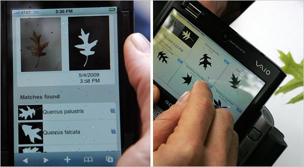
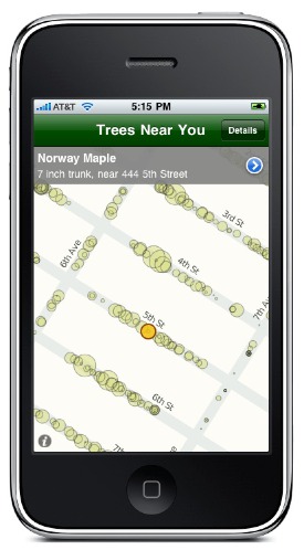
That is the beauty of Brett Camper's iphone app Trees Near You, which currently chronicles NYC trees, their locations, and not only environmental contributions, but economic. We've touched on merging factors of tech (here and here) and "nature" and how advancements in technology are becoming ubiquitous, and rather leading us away from nature, are re-introducing us to it.

The app which integrates with geo-location is the perfect, transportable system to not just learn the identification of trees, but better understand their role in an overall urban ecosystem. As the season's turn you'll no longer pass by, acknowledging them only as a spatial object, but they become personified as you notice the ever changing intricate characteristics provided by climate and season.

Currently the app is limited to the NYC area, but would imagine more cities are soon to follow.

Via GOOD

Related: Fieldwork | Mobile Tree Identification   We Can Play Our Cities Like Instruments

Local Codes | [Real] Estates

WPA2 : Local Code / Real Estates from Nicholas de Monchaux on Vimeo.

A finalist in the WPA 2.0 competition sponsored by UCLA Citylab, Nicholas de Monchaux and collaborators have provided a case study showing the impacts of the "spaces between places," spaces owned by the city but unused and still maintained. Monchaux's group, using geospatial analysis identify thousands of these publicly owned, abandoned spaces and quantify their transition into a network of urban greens.

Using San Francisco as a case study, the abandon spaces found happen to exist in areas heavenly burdened with energy efficiency and drainage issues, combining to make up an area that rivals Golden Gate Park. Local Codes/Real Estates, as the project is called, clearly displays the cost savings associated with eliminating needless infrastructural remediation while providing a healthy network of urban ecology.

Given the savings involved, this would seem quite actionable and applicable to any major city. With the intention of the individual spaces being designed by "hyperlocality," communities will be able to develop and fund their spaces to address specific needs.


WE are the Guardians of the Public Infrastructure

{Image via The Infrastructuralist}

We no longer have excuses for complaints that our voices cannot be heard.  Technology has given every imaginable way to organize and communicate against things we feel in the wrong.

Even in cities, above the car horns, street noise, and construction, means of pinpointing urban blight are here to give no room for them to be swept under the rug.

Through mapping technology, something I'm fond of seeing utilized in landscape contexts, is currently being developed in multiple facets in attempt to improve the lives of urban citizens.  I was recently contacted by the Environmental Mapping Technology Company SenSaris, after they read this post, to help design their personal, portable devices for measuring environmental conditions.

{Noise map around Bastille. Image via SenSaris}{SenSaris function diagram}

The mapping and measurements taken from the portable sensors directly correlate to inhabited areas to more efficiently influence which areas are in immediate of bioremediation or urban redesign.

At the social spectrum, the Infrastructionalist has created an interactive mapping system empowering citizens to pinpoint infrastructure degradation call F** This, Find It, Flag It, Fix It.  From their site:

In the land of F** This! you are granted many wonderful powers. You can become a guardian of public infrastructure. You can keep your city working smoothly. You can post pictures of busted crap–partially disassembled escalators in subway stations, cavernous potholes, permanently dark street lights–and trade snide and insightful comments with your wonderful new F** This! cyberfriends (why can’t your real life friends be this cool?). At the same time, while you’re busy enjoying yourself, we’ll see to it that the appropriate public officials get notified and the problem you identified gets dealt with. Or, if said officials prove useless in fixing the busted stuff, we’ll see to it that they endure at least some small measure of public humiliation. It’ll be fun!

{F** This map. Image via The Infrastructuralist}

While bureaucracies are a necessary evil, perhaps as tools like these become mainstays in our everyday use we become empowered to create the neighborhoods that we see fit.  If we don't, then it's a damn waste isn't it?

Fieldwork | Mobile Tree Identification

{Image via NYT. A prototype for an iPhone program, left, matches a picture of an oak leaf to a database. The prototype has been tested at Central Park in New York. Software to identify leaves by searching a field guide on a PC or a phone could be useful not only to hikers but also to scientists compiling data.}

It is important for a Landscape Architect to understand a wide variety about plants.  It is one of the many mediums used and the greater we can anticipate how a certain organism will react in a given environment, the more effective our selections will be.  

We are however not horticulturists, and the demand for us to be familiar with several disciplines limits the depth of how much we can know about each one.

Technology is coming to our aide.  And if we're criticized again by the likes of Will Alsop for not being able to identify a tree in the field, we'll simply respond, we don't have to!

A new application being developed by a team of researchers funded by the National Science Foundation gathers info from a database of thousands of images to enable you to properly identify a tree or shrub by using a photo taken from a mobile device.

As an intern or young employee, out in the field with the chore of identifying acres of existing plant life, this can be a daunting chore, especially if your plant i.d. isn't up to par.  Rather then returning to the office with hundreds of branches that you weren't quite sure of, take your iphone and handle it all in the field.

What would be the really interesting next step for this technology is to incorporate geospatial mapping to the photographed tree identity.  Once the tree is properly identified and tagged, it is recorded and color-coded onto a site plan, saving yet another step of compiling all of this field work into a accurate existing plant material plan. Perhaps even further down the road, certain infrared photo technologies will exist within smartphones that will also record and map plant health and existing ecology factors that might influence site planning matters.

+ Via The New York Times

Landscape Architecture and Environment Gauging Mobile Technologies

{An augmented reality architectural form, driven by real time environmental information such as temperature, brightness, humidity, wind direction and sound. nodes reflecting the sensor network are the seeds for the virtual architecture, growing and subsiding like an organism. Image via Information Aesthetics}

As technology advances our ability to extract and display information beyond simple pie charts and graphs present new possibilities for understanding our physical environments.  We recently discussed in our CityScene post how these new informational graphics are able to communicate the vast complexities that make up our cities, which more effectively equip landscape architects for proper design.  

The immediacy of social media networks like Twitter, as with the recent swine flu case, has shown how quickly information can be disseminated to the masses.  So why can't we as landscape architects adapt this ability to communicate the status of urban spaces and environments?

An article from SEED has us thinking that this is clearly possible.  “How would it change your ideas about moving around in the world, if you could suddenly sense things you couldn’t see?” asks Eric Paulos, an assistant professor at Carnegie Mellon’s Human-Computer Interaction Institute. Paulos wants to put tiny environmental sensors in cell phones and turn phone users into roving citizen scientists who continuously sample and respond to their personal environment. This type of local and real-time environmental data would not only facilitate science and satisfy individual curiosity, it will empower people to uncover, visualize, and collectively share information about their own neighborhoods and cities. It could ultimately encourage active participation in protecting and improving those spaces.

{Image via Information Aesthetics}

Armed with this new environment gauging technology, spatial and environmental data could be sent to city planning office hubs, which a program monitors and automatically records and displays the readings via data visualization tools.  Geo-spatial mapping taken from camera phones, cell phone usage monitoring will reveal real-time urban space usage and tell the effectiveness of these areas.  Certain cell phone technologies that are able to detect moods from visitors once recorded will also enable psychology of space mapping.

These technologies will also monitor urban micro climates, and any pollution effecting these areas, which will allow officials to immediately act to resolve any issues.

{Image via Information Aesthetics}

This has vast implications for landscape architects.  Much of our work is commissioned after long and laborious case studies show that a certain space has been improperly designed or simply no longer relevant due to an evolving cityscape.  By this time, complete and costly renovations have to be made, but long after these spaces have laid in a state of social and environmental disrepair.

With advanced interactive environment gauging mobile technologies, landscape architects can be quickly and more abundantly engaged in design solutions.  They'll immediately be provided with the recorded mappings and data visualization graphics which they will use to resolve urban design and environmental inefficiencies.

During this time of severe economic slowdown, we as landscape architects need to embrace a paradigm shift of how we approach the profession and become a part of the design and development of advanced social/environment measuring media, not only will it better equip us to properly do our jobs, but it will provide vast amounts of work for our profession.

Let's get a dialogue going of the possibilities. 

{In this visulisation the height of each track point indicates that individuals physiological arousal at that geographic location. Image via BioMapping}{Detail of Greenwich Emotion Map. Image via BioMapping}+ Information Aesthetics

+ BioMapping

+ Related | CityScene | Urban Biorhythmicity | SpatialKey: Geotemporal Mapping